
by Nashon Adero, John Ngugi, Bonface Odhiambo, Taita Taveta University (TTU) – KENYA.
How many of us remember the floods of 2024, when some Nairobi residents had to use boats to access their leafy suburban homes? We wrote about it, but the warnings were never heeded, or else better preparedness would have been evident. Now we are back to the same crisis, and we have to write again.
Based on Systems Thinking, we understand and reiterate that:
- perceptions lag reality,
- working from whole to part is king, and
- dividing an elephant in half does not produce two small elephants.
The fragmented way in which decision-makers have been handling the cyclic crises of floods and subsequent droughts in Kenya betrays a chronic disregard for geospatial expertise, science, and systems thinking.
Why Data and Expertise?
Geospatial expertise, mainly, is key to anticipating, organising, perceiving, and interpreting location-based events, trends and patterns over time on Earth. Floods are typical of such events whose location-specific geography must be well understood to inform predictive, preventive, or management measures. For example, the rising accumulation of the solid waste that clogs drainage channels in the highly populated city of Nairobi has strong geospatial dimensions.
Expert advice informs decision-makers of the critical need to moderate construction in a way that can reduce the paved areas to green areas ratio, or the parking lots to parks ratio. Do they listen and act? Poor practice persists: we seal town centres with concrete completely without porous spaces and green areas to ensure rainwater infiltration and reduce runoff speeds. The increased stormwater discharge and the compounded kinetic energy of the flowing water eventually does “great work” along its path downstream (remember, energy is the ability to do work). Do we need to continue complaining? Basic applied science is talking here!
With advances in data acquisition and mapping technologies, the actionable location-based intelligence and shared visual evidence from the surveying, Earth observation (EO), and geospatial mapping products and services are readily available for risk modelling, hence paving the way to derisking by reducing uncertainties into quantifiable risks. The resulting information is crucial for informing timely and effective derisking mechanisms.
Deformation monitoring, a critical aspect of maintenance engineering, must be practised routinely to forestall the recurrent floodgates of disaster experienced during heavy rains, collapsing dams and buildings being ready examples.
The preceding statements lay a robust foundation for the lucid argumentation asserting that there has been a wanton disregard for data, expertise, and sound science in the weak, haphazard, rhetoric-heavy, and mainly reactionary disaster governance paradigm that has become normal practice among Kenya’s elected leaders. Though not pre-empting in any way what the professional bodies are likely to champion during the upcoming tirades, if not constructive dialogues, on the flood crisis, this IBD Special issue is bold and assertive on the need for a culture change to tap into the pool of expertise and technologies that are fit-for-purpose and fit-for-context for enhanced disaster governance in Kenya, even as population and urbanisation increase.
A Decision Crisis
Decision Science is critical in the face of the flood crisis Kenya is grappling with, as heavy downpours rage relentlessly. Though the two protagonists of Decision Science, Daniel Kahneman and Jay Forrester, have exited this earthly scene, their key contribution to this field lives on. The skewed behaviour of humans, expressed in underestimating likely outcomes and overestimating the less likely events, has been well observed and documented. In System Dynamics, we understand that perceptions lag reality, working from whole to part is king, and dividing an elephant in half does not produce two small elephants. Piecemeal interventions with accusations and counteraccusations cannot salvage the situation at hand, whose cure lies in a government-led, whole-systems approach.
Elected leaders must wake up to the fact that when academics and researchers put forth these compelling suggestions, they are not pleading for attention or allowances. On the contrary, they are answering their higher call of duty, refined over decades in the sizzling salt of scholarship.
The fragmented way in which decision-makers have been handling the crises of floods and subsequent droughts in Kenya betrays a chronic disregard for expert advice. Roadside policy declarations not founded on data and science have only deepened the decision crisis. Long-term planning suffers as a result, exposing gaping holes in strategy and policy design. Yet, the gap is not prevalent because of a lack of decision support models, but because of a malevolent neglect of the available and suitable decision support tools and the expert champions of such.
Reactionary Rhythms in a Predictive Era?
The flooding crisis in Kenya and the sure drought crisis that will follow constitute a predictable cycle. In response, decision-makers have been swift to disregard early warning messages from experts, at a time when predictive models have been getting better and better with advances in geospatial data quality and geodata processing and modelling techniques and technologies. Disaster risk mitigation can only get better with predictive models, making it pathetic for a country to front reactionary responses, which are already far removed from preventive measures and light years behind the aspirational predictive measures that are becoming the rule in the era of Big Data and Artificial Intelligence (AI).
Forgotten Disaster Governance Lessons
The COVID-19 pandemic bequeathed us lessons on disaster governance, which were documented in the book entitled The Future of Africa in the Post-COVID-19 World, co-authored by African scholars and published in 2021 by the Inter Region Economic Network (IREN) – a private think tank. Politicians are loud, watching as the number of flood victims in Kenya remains high and counting. Now, so evident is the ill-preparedness of government in all the 7Ts outlined as pillars of disaster governance in the book: Timing, Testing, Tracing, Transparency, Trust, Training, and Transdisciplinary Thinking (read more from page 5 of the book: The Future of Africa in the Post-COVID-19 World (April 2021). Inter Region Economic Network).
The Promise of Geospatial Modelling
Quality decision-making against geohazards (e.g., floods, landslides, sinkholes, earthquakes, tsunamis, etc.) heavily depends on geospatial modelling and mapping with actionable visual evidence at scale. A scan of the flooding hotspots reveals a ready visual answer in geospatial modelling, with the map below displaying evident topographical predispositions by precise geolocation. Nowadays, unlike in the 1990s and earlier, we can readily extract such decision-support data and information from medium- to high-resolution satellite imagery and detailed geospatial surveying techniques e.g., terrestrial and airborne LiDAR/laser scanning and use of Unmanned/Uncrewed Aerial System Surveys to remotely collect key geodata and generate 3D models, including digital terrain models and even the more progressive products of extended reality such as Augmented Reality (AR), not to mention Digital Twins, all of which are key to modern and innovative facility and infrastructure management (Read more from this recommended reference practice-oriented book: Project Design for Geomatics Engineers and Surveyors, Second Edition: Amazon.co.uk: Ogaja, Clement, Adero, Nashon, Koome, Derrick: 9781032266794: Books)
Again, open geospatial data portals nowadays avail analysis-ready data (ARD) in support of disaster-mitigation models and Early Warning Systems (EWS) e.g., from SRTM (Shuttle Radar Topography Mission), Digital Earth Africa (DEA) and Esri Living Atlas.
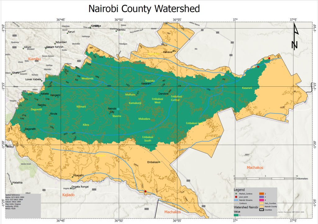
Map of the Nairobi City County Watershed: Evident display of the topographical susceptibility of Kasarani and Starehe areas to flood waters. See the elevation in metres and slope from the contours. Map makers: Nashon Adero, Bonface Odhiambo, John Ngugi, Taita Taveta University (TTU), using ArcGIS Pro (licensed through Esri Eastern Africa under the Esri education site license software support).
Watershed modelling displays at scale, to all and sundry, how flow accumulation points are spread across space over time (see the map below). There is no shortage of Surveyors and GIS & Remote Sensing experts, who together provide the skills to share the evidence base to deal with floods through adequate spatial planning, complete with informed policy enforcement and compliance monitoring. Policy enforcement or lack of it due to corruption or otherwise, and the wanton disregard for professional guidance and advice, together expose the dearth of a groomed culture and national values in Kenya.
Spatial Distribution of Flow Accumulation and Runoff Convergence in Nairobi County
The map shows flow accumulation across Nairobi County, with drainage lines, sub-counties, markets, and mapped pour points. The strongest accumulation is concentrated along the eastern and especially north-eastern parts of the county, notably around Kasarani and the Embakasi corridor, where yellow, orange, and red stream segments mark progressively higher flow concentration. Much of the rest of the county remains in lower accumulation classes, shown in dark green, with moderate convergence through parts of the central urban belt.
This pattern suggests that runoff from multiple upstream areas progressively converges into fewer, more defined drainage channels toward the east and north-east, making these corridors more hydrologically sensitive and potentially more susceptible to concentrated flooding, channel erosion, and stormwater management pressure. The red pour points likely represent key outlet or drainage exit locations where accumulated flow leaves local catchments.
Flow accumulation units: in GIS hydrological analysis, flow accumulation is measured as the number of upstream raster cells draining into a given cell, so the legend values are cell counts. These can be converted into contributing area in square metres (m²), hectares (ha), or square kilometres (km²) by multiplying by the area of one raster cell, which depends on the spatial resolution of the imagery (e.g., 30 m x 30 m for each cell in this SRTM extract, such that the highest accumulation value on the map of about 430,000 cells corresponds to an upstream contributing area of about 390 km²).

Map of flow accumulation in the Nairobi City County confirming the susceptibility of Kasarani and Embakasi areas to flow accumulation during heavy rains (red flow lines as shown in the legend). Map makers: Bonface Odhiambo, Nashon Adero, John Ngugi, Taita Taveta University (TTU), using ArcGIS Pro (licensed through Esri Eastern Africa under the Esri education site license software support).
Conclusion
While one may rightly contend that the habit of casually ignoring repeated warnings against settling in riparian zones and other disaster hotspots is reprehensible, disaster prevention demands far more than leaving matters to the whims of citizens. Government, at both the national and county levels, bears a critical and inalienable responsibility to facilitate, enforce, and monitor compliance in matters of proper urban planning, urban design, and sustainable water and waste management.
Indeed, ready interventions are not lacking. They can be found in the facilitation of waste-to-energy solutions for urban households, especially within the informal settlements that constitute much of the highly populated urban primate of Nairobi. Equally, there is urgent need to invest in water storage during seasons of heavy rainfall so that the drought cycles that follow do not bite with such ferocity. There are already scalable prototypes in community-led socio-economic transformation. A notable example is the Manyatta-Kisumu Geodesign and citizen-led informal settlement transformation project, which a US and Kenyan team of scholars, youth, community leaders, and professionals successfully implemented on the ground in 2019.
Further, the menace of plastic waste, which is central to the drainage crisis during heavy rains, can be tackled more effectively if innovative prototypes such as the student-led Tunza Mazingira plastic circularity project by the Enactus Club Chapter of Taita Taveta University can be scaled up. Yet such promising individual initiatives can only yield meaningful transformation when backed by deliberate government support and scaling mechanisms, complete with government-led incentives for active private sector participation.
Resolute governmental action, anchored in data, models, and sound science as advised by experts, is therefore where moral force and life-enhancing governance ought to reside. To do justice to the evidence already before us — particularly the half-hearted and lackadaisical manner in which Kenya has involved experts in key decision-support committees and commissions, and the repeated neglect of professional and scholarly advice — one is left with the logical conclusion that the larger share of the blame rests with the Government’s ill-preparedness, together with its weak and belated response to the flood crisis.
John Ngugi and Bonface Odhiambo are graduates in BSc Geoinformatics from Taita Taveta University (TTU). Like many other students and graduates of TTU, they are among the youth mentees of Impact Borderless Digital (IBD) who benefit from the gap-filling youth talent and career mentorship sessions IBD regularly conducts outside the four walls of the classroom, which is a deliberate departure from the traditional linear brick-and-mortar approach to training. As a geospatial expert and Mentor under the FIG Mentoring Programme for Africa as well, the Founder of IBD (Nashon Adero) is passionate about mentoring the youth in geospatial skills and career development, besides other productivity and networking skills for the borderless and digital 21st-century workspace.
Well put, I wish African leaders could stop being allergic to expert opinions and data
Insightful and timely read. The article clearly demonstrates how the flood crisis in Kenya is not merely a natural disaster but also a governance and planning challenge. The emphasis on geospatial data, systems thinking, and evidence-based decision-making is especially compelling. It is encouraging to see experts and young professionals from Taita Taveta University contributing practical insights and highlighting how modern tools like GIS, remote sensing, and predictive modelling can help mitigate recurring disasters. Hopefully, such evidence-driven discussions will inspire policymakers to prioritize data, expertise, and long-term planning in disaster management. Well done to the authors for raising this critical conversation.
Data insights should never be ignored. From the next elections, Scholars should embrace elective politics; they affect us directly.
Academia’s voice gains influence when it avoids blame, moves beyond commentary, and demonstrates commitment through concrete action. Instead of lamenting limited space or support, scholars must pair critique with implementable, end‑to‑end solutions – piloted where possible – to signal seriousness and earn government attention. The absence of such practical demonstrations has kept much African research confined to theory, with little policy traction. Proposals should therefore be fully visualized, actionable, and grounded in real‑world trials to open the door for deeper engagement. The article is otherwise well written and well-intended. Keep it up!
Refer to the MANYATTA-KISUMU GEODESIGN PROJECT by scholars, which is already a practical and scalable prototype. Politicians control resource distribution, and the resources need to be prioritised to follow such working examples that scholars have already put forth.
this is the most exhaustive analysis on the city’s flood water management concerns and reminding us that we must effect and institutionalize hydrological barriers to buffers by storing floodwaters and attenuating peak flows. Sustainable Urban Drainage Systems are a must. Disaster Management is not for cronies but rather technocrats who are passionate about their jobs and universal role for our well being as a nation.
This is a well structured and impactful study. Nashon Adero clearly demonstrates the complex causes and consequences of flooding in Kenya. The use of geospatial perspectives strengthens the analysis. Including more case studies or community level adaptation strategies could further enhance the practical relevance. Overally, this is an important contribution to climate and disaster research.